FAQs
- Road
- Rail-Ferry-Rail
- Rail.
- The bridge design concept and the crossing location are the same as that approved by Bundaberg Regional Council in 2015 under an Operational Works development permit, by the Department of Environment and Heritage, the Department of Agriculture, Fisheries and Forestry, the Department of Transport and Main Roads (Maritime Safety Queensland) and Gladstone Ports Corporation.
- The location comprises a modified environment that will introduce minimal additional impacts, including minimal impacts to terrestrial and marine vegetation and habitat.
- The location is proximate to connecting cane rail networks.
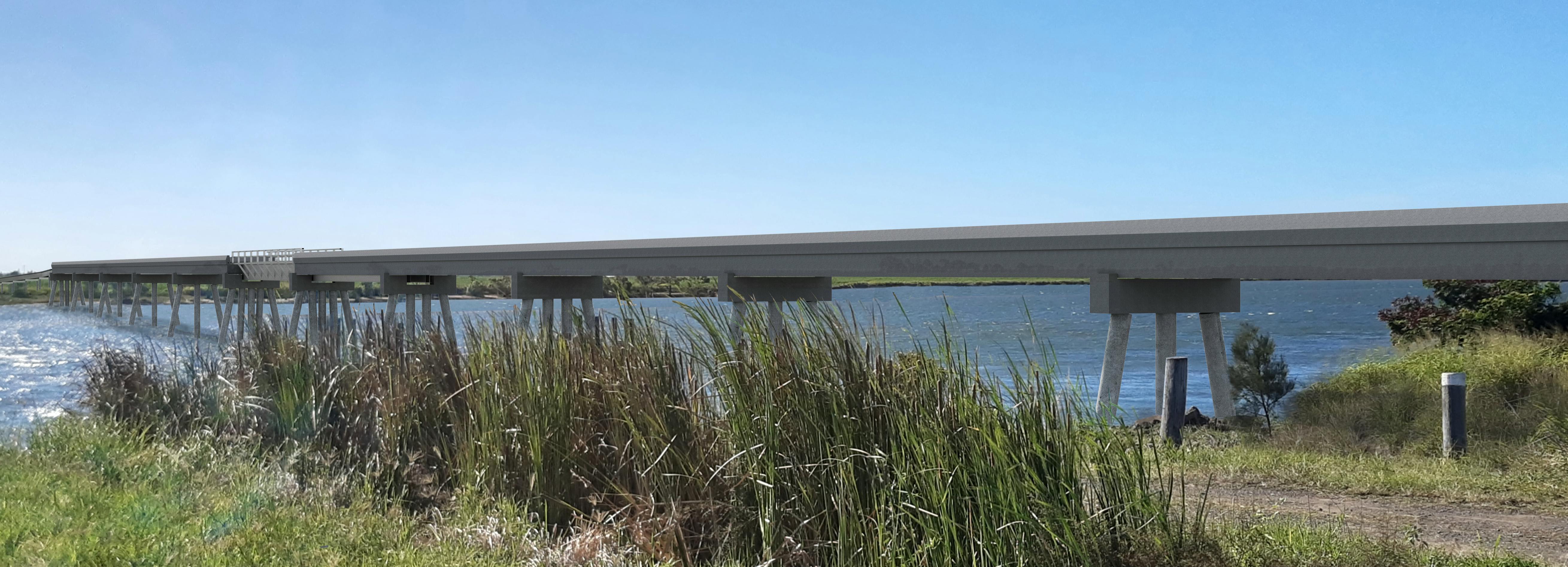
- The location has a relatively short river crossing (approximately 275 m) with clear visibility of the proposed bridge for river traffic.
- The location minimises disruption to existing public infrastructure.
Why is Bundaberg Sugar going through an infrastructure designation process instead of the usual development application process?
Council, with the endorsement of the Department of Environment and Heritage, the Department of Agriculture, Fisheries and Forestry, the Department of Transport and Main Roads (Maritime Safety Queensland) and the Gladstone Ports Corporation, gave an Operational Works – Prescribed Tidal Work (Cane Rail Bridge) approval on 30 March 2015 for the same bridge design at the same location.
To enact this approval, Bundaberg Sugar is required under the Planning Act 2016 to obtain a separate land use approval.
The bridge and ancillary approach rail infrastructure is proposed over freehold and State-owned land. It is proposed on premises under the town planning jurisdiction of the Office of the Coordinator-General and Bundaberg Regional Council.
The regulatory framework introduces different assessment managers applying different assessment benchmarks under different procedural systems for various components of the project. This multiplicity of variables introduces the potential for disjointed and extended assessment timeframes.
Bundaberg Sugar elected to request Council to make a local government infrastructure designation, as provided for under the Planning Act, because it was thought to be a more coordinated, streamlined and transparent process.
Why does Bundaberg Sugar need to build a bridge?
Closure of the Bingera Mill after the 2020 crush necessitates the transportation of about 450,000 tonne of cane from north of the Burnett River to Millaquin Mill on the south of the river. Bundaberg Sugar considered three (3) transportation options-
The road option would introduce more than 48,000 additional heavy vehicle movements onto the local and State road network during the crushing season. This is not a financially sustainable option in the longer term and it would place a burden on the road network.
The rail-ferry-rail option would reinstate the former cable ferry that was washed away in the 2013 flood. It would involve transporting cane by rail to Bundaberg Sugar’s roll on/roll off facility at Lot 5 on RP41027 at River Road, thence trucking the cane via ferry to a second roll on/roll off facility at Lot 1 on SP187609 (Barrons Road) where it would be transported by rail to Millaquin Mill.
The rail-ferry-rail option is susceptible to flood events and the road transport costs are prohibitive in the long term.
The rail option is the only financially sustainable option. Bundaberg Sugar believes it also introduces fewer social and environmental impacts.
It is noted that after crossing the river and connecting with existing BSL cane rail infrastructure in the vicinity of Strathdees Road, the cane will be transported to Millaquin Mill via approximately 8km of existing cane rail network. This existing rail line runs through Rubyanna (along part of the Barrons Road road reserve and through land owned by BSL), Kalkie (alongside McGills Road) and Bundaberg East (along part of Alexandra Street), before reaching Millaquin Mill.
Why is the bridge proposed at this location?
This location was chosen for a number of reasons:
Will vessels still be able to transit up and down the river?
This question should be considered in both the construction phase and the operation phase of the bridge.
Construction
Section 2.2.2 Construction' of the EAR identifies two bridge construction methods. One method involves a cableway system. This involves slinging a cable between two temporary towers constructed either side of the river and utilising a skyhook to lift and transport loads. The second bridge construction method involves the use of barges in lieu of a cableway system. This technique utilises an unpowered barge with piling rig and crane installed and a separate, unpowered flat top barge used as a supply barge.
The river remains navigable under both construction technique scenarios for the majority of craft. This matter is discussed in detail at 'Section 11.2 Construction' of the EAR.
The reason two construction methods are considered is because of the magnitude of the investment. A formal review process will be undertaken by BSL for final confirmation of the construction company and therefore the construction methodology once the infrastructure designation request has been approved and approval conditions are known.
Operation
During the non-crushing season, nominally between December and June, the bridge will remain in the open position allowing vessels to pass freely up and down river.
During the crushing season, the bridge’s retractable span will be in the closed position. The underside of the bridge deck will be 3.5 metres above highest astronomical tide (just above the modelled 2013 peak flood level). Vessels with an above waterline height of less than 3.5 metres will therefore be able to pass through the bridge on any tide up to the highest astronomical tide. Lowest astronomical tide clearance will be some 7.1 metres
Vessels that require the bridge to be in the open position to transit through will need to contact the Cane Transport Traffic Control Office located at Millaquin Mill. This office is manned 24 hours, 7 days a week during the crushing season. Vessels will be able to pre-book opening times with this office; unscheduled and/or emergency openings can be undertaken by phoning the Cane Transport Traffic Control Office.
Stakeholders who have an on-going interest in having a vessel pass through the bridge will be provided with the direct phone number for the Traffic Control Office. This number will also be displayed at the bridge in the line of sight for vessel skippers and available on Bundaberg Sugar’s website.
What if a vessel or if debris hits the bridge in a flood?
The bridge has been designed in accordance with Australian Standard AS5100-2017 Bridge Design series.
‘Section 15.4 Collision from waterway traffic’ of AS5100-2017 requires bridge piers to be designed to absorb collision impact energy or resist the collision forces from the ‘design craft’. The design craft is specified by the relevant authority, in this case the Harbour Master.
Following consultation with the Harbour Master, the adopted design craft is a 100t fishing trawler and the adopted design velocity is 10 knots. The bridge piers are designed to absorb collision impact or resist collision forces from a 100 tonne vessel moving at 10 knots.
The bridge has also been designed to withstand hydraulic loadings associated with flood forces up to 1:2000 ARI flow and height, including impacts of debris and log collision.
What will be the environmental impact?
The alignment of the infrastructure follows a modified corridor which displays lower environmental values than found elsewhere along the Burnett River’s riparian boundary.
Matters of national, state and local environmental significance were reported on by GHD in July 2014 (as part of the Operational Works development application lodged with Council and referred to the State Government) and then tested for currency by Wide Bay Burnett Environmental in June 2021. Their assessment was that the project will not diminish significant environmental values in or adjacent to the development footprint.
With respect to marine turtles, Bundaberg Sugar has adopted ‘turtle friendly’ lighting in terms of colour, intensity and direction of illumination.
In terms of turbidity, the in-river disturbance footprint will be kept to a minimum by incorporating piles in the design. The use of piles minimises the construction footprint, replaces the need for formwork and reduces turbidity by sucking riverbed material up through the circular steel chamber.
Irrespective of the method of construction, the environment is proposed to be protected by complying with Conditions 1-12 and Conditions 19-22 of the Department of State Development Infrastructure and Planning concurrence agency response dated 23 December 2014 (Ref: SDA-0814-013294).
Both the Department of Environment and Heritage and the Department of Agriculture, Fisheries and Forestry supported the bridge and approach trestle location in their 2014 conditional approvals.
When would the bridge be built and how long will it take to build it?
Several variables extraneous to the infrastructure designation bear upon the commencement of construction. One pivotal consideration however will be the Board of Bundaberg Sugar Ltd being agreeable to any conditions or requirements attaching to the approval/designation.
Construction is likely to take twelve (12) months but a construction period of eighteen (18) months has been factored in to accommodate unforeseen delays.
Where can I get more information about the proposal?
Council holds all plans and reports relevant to the proposal. Access to these documents is available on this project page
If you would like to talk to someone about the project, you can contact Mr Evan Fritz, Manager Strategic Planning at Bundaberg Regional Council on 1300 883 699.